

Enhancing Event Construction with Drone Progress Photography: A Case Study...
Read MorePre Hurricane and Post Hurricane Drone Services
Drone Based Storm Documentation that protects
Pre Storm Services
Post Storm Services
Long Term Solutions
Hurricanes: Its Personal this time
Drone based documentation for storms and hurricanes took off after Hurricane Irma in 2017. ProDrones was in the center of that storm and set out to revolutionize how data is handled before, during, and after hurricanes. To make regular documentation affordable, we approached 3 main verticals that can use data gathered for pre-storm operations. Amortizing the cost of documentation across existing day-to-day activities allows our clients to save more than they spend, making drone based storm documentation extremely affordable in the long run.
Take THe Insurance Initiative
When it comes to big storms like hurricanes, insurance companies are notorious for the 3 D’s of adjusting: Delay, Deny, Defend. The best way to help expedite your claim is to document your loss. In order to do document loss, often companies argue against pre storm conditions that property owners do not often document. Enter ProDrones. We make it easy and affordable to regularly document your properties’ condition on a recurring basis, using the data in your day to day operations to improve value and affordability.
Documentation You can acutally use
Our services and software make it easy to create, report, share, and understand the data you are getting. Need to add your landscaper to a map? No problem, no costs. Just simple, straight forward solutions for hurricane and storm documentation. You have enough to worry about when it comes to storms. Let us take documentation off your plate.
Software Built for Storm Assessment
Whether you are looking to document your property before or after a storm has hit, ProDrones Viewer programs make it easy, straight-forward, and simple.
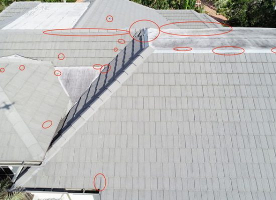
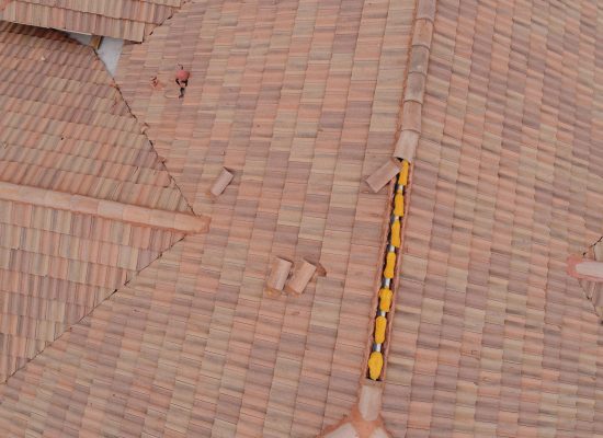
- InspectionViewer – Our inspection viewer provides detailed inspection analysis for roofing, windows, building facade, and more. This tool combines mapping overlays with drone imagery to show you right where each image was taken. It also provides altitude and time data so your team can easily understand the context of your inspection data.
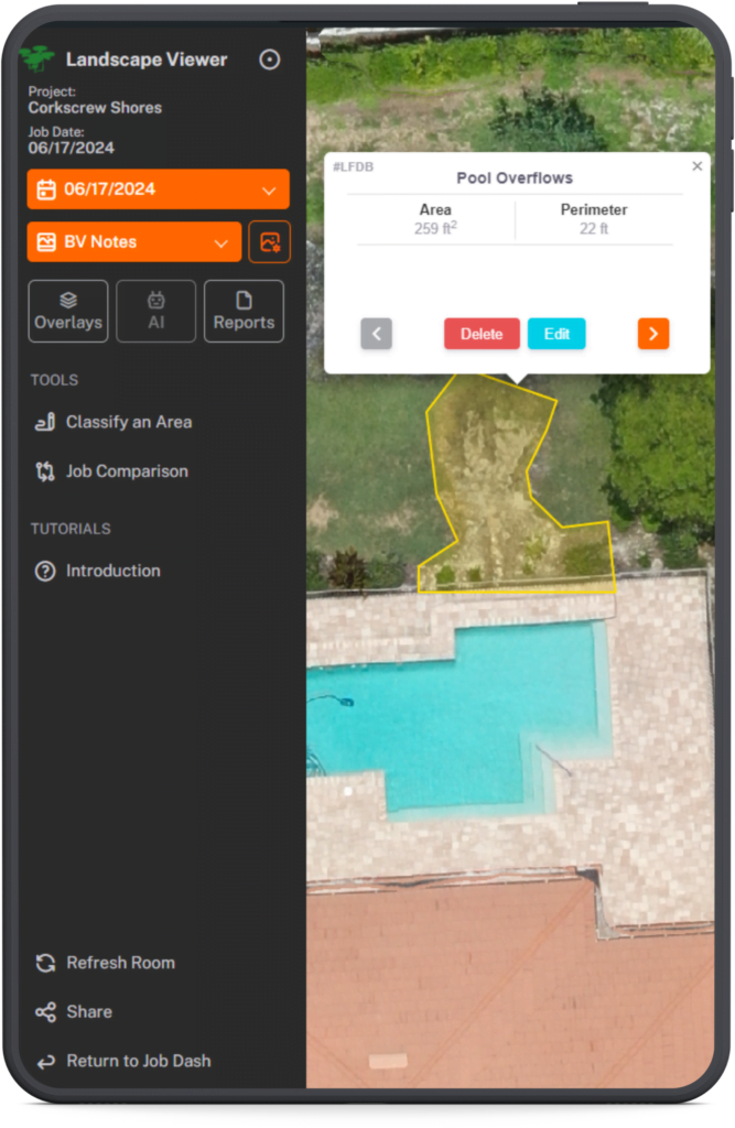
- LandscapeViewer – Shown Left (above for mobile), LandscapeViewer provides affordable, simple documentation on larger sites. Recommended for properties 5-1500 acres, our LandscapeViewer transforms the process of documenting bigger sites. Instead of hundreds or thousands of images, our proprietary software stitches those images into a single map, simplifying your workflows. This provides before and after comparison tools, map annotation tools, and reporting functions that export to a geotagged PDF.
- CommunityViewer – Our CommunityViewer software provides affordable, simple documentation on larger sites. Recommended for properties 5-1500 acres, CommunityViewer ties into property databases to provide context to your mapping data. This tool assists with day to day activities in communities making it easy and affordable to keep your community documentation up-to-date.
- ConstructViewer – ConstructViewer provides affordable, simple documentation on larger sites. Recommended for properties 5-1500 acres, our ConstructViewer transforms the process of documenting bigger sites. Instead of hundreds or thousands of images, our proprietary software stitches those images into a single map, simplifying your workflows. This provides before and after comparison tools, map annotation tools, and reporting functions that export to a geotagged PDF. This product is ideal for HOAs under construction, commercial properties, and more.
How our clients benefit
Our drone services simplify storm damage documentation by handling the entire documentation process. We fly, process, and deliver amazingly detailed pre storm and post storm imagery. From a single family home to a 50 acre strip mall to a 2500 acre master planned community, our system makes it not only simple but also affordable to regularly document your property against storm damage. Our system begins with regular drone fly-overs and delivers high-resolution maps directly to your computer. We take care of the logistics, including pilot scheduling, data processing, and ensuring compliance with all necessary regulations, so your team doesn’t have to worry about insurance, aircraft maintenance, or liability. With our advanced software and custom-built computers, we process the raw data into maps with up to 10x the resolution of popular mapping apps like Google Maps, delivering your project in just 2-4 days.
Once your map is ready, we upload it to our secure servers for easy access, allowing your team to view, analyze, and annotate the data quickly—saving hours compared to traditional methods. Depending on your package, we offer storage for live maps for a minimum of 12 months, with options for long-term storage up to 5 years. Whether you need immediate insights or long-term data retention, our drone services are designed to make storm documentation and day-to-day management more efficient and effective. You have enough on your plate planning for hurricanes, why worry about managing the drone guy in the middle of storm prep? Professional Drone Solutions is your trusted provider in hurricane documentation and insurance disputes.
Our Softwares Features
- Map Style Viewer
- GPS Enabled Report Flags
- Date Stamp on Every Flight
- Create Project Management Punch-out Lists
- View Changes Overtime
- Comparison View
- Historical Weather Data
- Reports By Categorization
- Inspection Reports with time and date
Your benefits
- Document Large Projects
- Document Against Storms
- Streamline Damage Assessment
- Simplify Proof of Loss
- Locate Damaged Areas Quickly
- Generate Reports in a Click
- Improve Contractor Coordination and Planning
- Improve Oversight and Accountability
- SAVE more than you SPEND through operational efficiency
How Drones Help you Document


Before
After
Progress over time
Documenting commercial sites and communities against storm damage is challenging. Showing changes over time empowers our clients by proving what has changed on your site or in your community. Having factual documentation reduces insurance conflict.
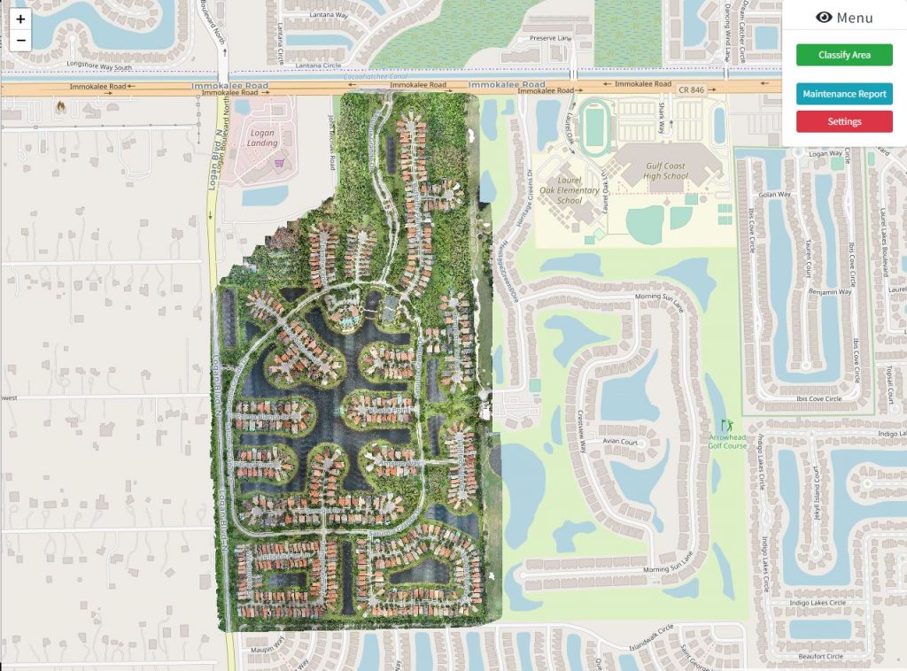
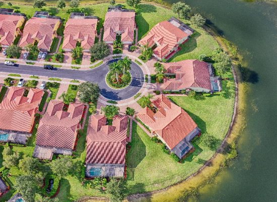
View entire communities
Our drone based storm documentation tools start with complete documentation of the entire property in one image. This makes the process of viewing projects extremely natural. How long would it take you to walk the whole property or an inspection?
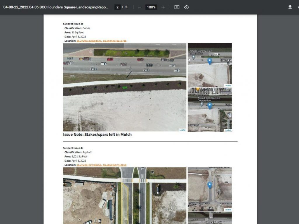
Generate automated reports
Generate reports with one click, making damage management and mitigation a breeze. Identifying issues quickly and proactively solving problems saves relationships with property owners and stakeholders. The best part? We built intelligent features into our pdf reports. Click the GPS coordinates to open your devices mapping app and walk right up to the problem area!
Craving More Info? Read our blog.

Discover the World of FPV Drone Videos
Introducing FPV Drone Videos: Experience a New Perspective FPV Drone...
Read More
Exploring Drone Altitude Limits: 400 ft Rule
Understanding the 400-Foot Rule: How High Can You Fly Your...
Read More
Accelerate Sales with Drone Videos
Selling Properties Faster with Drone Videography In today’s competitive real...
Read More