

Enhancing Event Construction with Drone Progress Photography: A Case Study...
Read MoreDrone Services for Landscape Management

Drones Help Landscaping Companies
Save Time
Traveling to sites is one of the biggest time commitments managers have. Our software replaces site visits for senior staff members, saving time and increasing oversight. Monthly virtual site walks actually get done. Our clients see as much as a 50% decrease in time managing sites, while providing oversight that makes their clients feel cared for. With the data accessible to multiple people, you can be sure everyone is on the same page.
Save Money
Our service saves our clients money in a number of ways. Being able to see the job your project manager is doing means fewer site visits for executives. More oversight means better products for your clients. Proof of conditions means fewer arguments, improved customer retention, and improved close rate on sales.
Reduce Churn
Do you know how much money losing a client costs? Losing a HOA contract can cost landscapers millions in lost revenue and tens of thousands in sales efforts to replace that client. LandScapeViewer improves communication and quality by showing clients site improvement, providing historical weather data, and provides a platform to easily communicate when the unexpected does happen. Our clients spend less than 1% of their contract on our services and retain clients at a significantly higher rate than the average.
Welcome to the Landscape Viewer
Landscaping companies have long faced struggles with client acquisition, project management and transparency, client retention, and executive oversight. Professional Drone Solutions has developed Landscape Viewer to solve these issues.
- Client Acquisition – our reports make it easy to see what homes are in compliance. Because all homes are recorded and stored, it is fair and equitable. Its also more conducive of privacy than having compliance officers walk other peoples properties.
- Project Management – Using Landscape Viewer, project managers see their entire site at least once a month. With our interface they are able to easily make annotations and generate reports to rapidly and proactively solve clients problems. Having the entire site documented helps conflicts get resolved based on factual reporting. Clients can view their historical data and easily see when, where, and potentially why certain areas are having problems.
- Customer Retention – The ability to proactively identify issues, readily coach and train employees, and increased oversight allows teams to meet the needs of their clients before issues occur. This change leads to a shift in how clients are served. The factual presentation of data doesn’t just allow you to better manage your projects, but also track progress on areas that are causing conflict between client and customer.
- Executive Oversight – Before Landscape Viewer, any executive oversight included lengthy travel, a day on site, calls ahead to HOA management, all just to walk around part of a community. Executives rarely got to see the entire project. With Landscape Viewer, this all changed. With our software executives can effectively and efficiently coach their management remotely, with easy visual access to entire projects. Executives can view multiple sites a day, ensuring quality standards are upheld. This allows your best project managers to do more work in less time with less stress, allowing landscaping companies to retain, train, and utilize employees much more efficiently.
How our clients benefit
Our drone services simplify landscape management by handling everything from monthly drone fly-overs to delivering high-resolution maps directly to your inbox. We take care of the logistics, including pilot scheduling, data processing, and ensuring compliance with all necessary regulations, so your team doesn’t have to worry about insurance, aircraft maintenance, or liability. With our advanced software and custom-built computers, we process the raw data into maps with up to 10x the resolution of popular mapping apps like Google Maps, delivering your project in just 2-4 days.
Once your map is ready, we upload it to our secure servers for easy access, allowing your team to view, analyze, and annotate the data quickly—saving hours compared to traditional methods. Depending on your package, we offer storage for live maps for up to 12 months, with options for long-term storage up to 5 years. Whether you need immediate insights or long-term data retention, our drone services are designed to make landscape management more efficient and effective.
Our Softwares Features
- Map Style Viewer
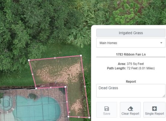
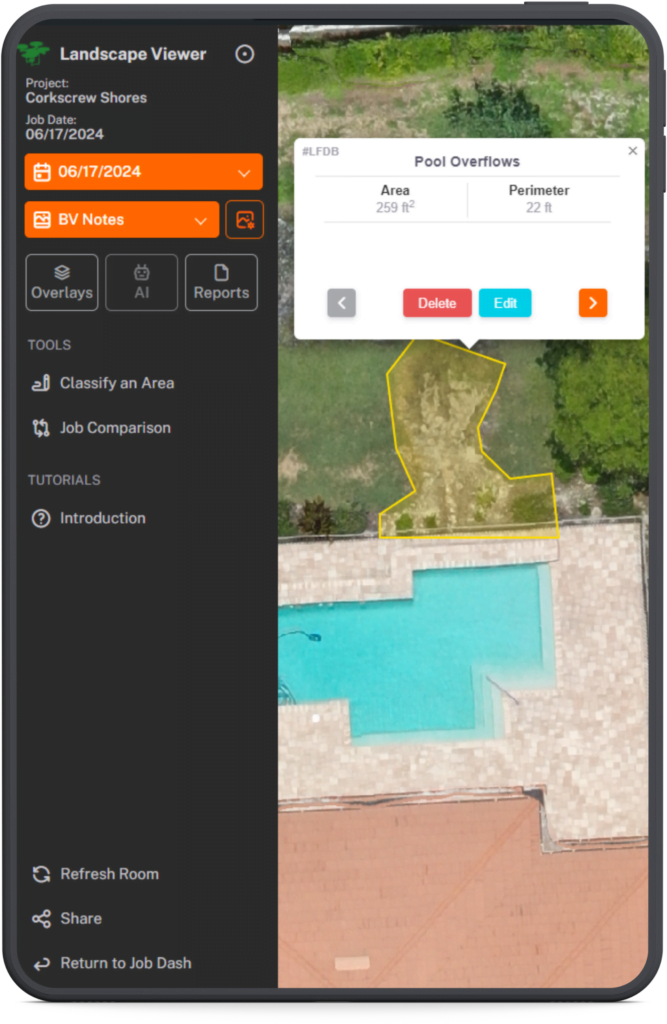
- GPS Enabled Report Flags
- Date Stamp on Every Flight
- Create Project Management Punch-out Lists
- View Changes Overtime
- Comparison View
- Historical Weather Data
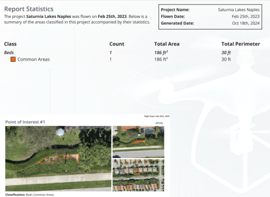
- Reports By Categorization
- Estimation Reports
Your benefits
- Document Large Projects
- Streamline Project Management Reporting
- Generate Reports in a Click
- Create Project Management Punchout Lists
- Retain More Clients
- Acquire New Clients Easily
- Improve Employee Training
- Improve Oversight and Accountability
- Improve Transparency and Client Communication
Issues Clients Have Identified
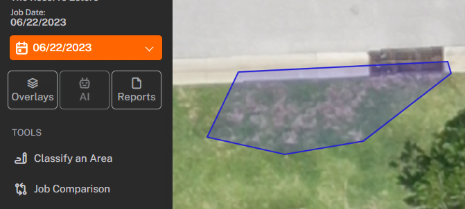
Bug and Fungus Damage
Drone imagery provides landscapers with a bird’s-eye view of your entire project, enabling the early detection of chinch bug and fungus damage in grass through high-resolution photos that reveal the affected areas. This advanced perspective helps in precisely targeting treatment efforts, saving time and resources by addressing issues before they spread extensively.
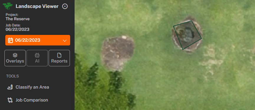
Dead and Missing Trees
Drone imagery allows for quick identification of diseased and dead trees, facilitating targeted care and preventing the spread of disease across landscapes. Our Viewer streamlines the management of tree health, ensuring timely and effective interventions.
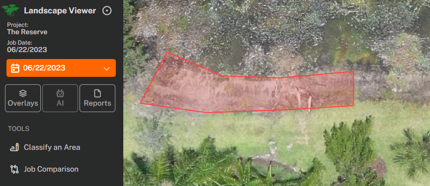
Lake Bank Erosion
Drone imagery aids in identifying bank erosion and the health of littoral plants, enabling precise conservation efforts to protect shorelines and aquatic habitats. This approach enhances the effectiveness of restoration strategies.
How Drones Help Landscapers


Before
After
Progress over time
Providing landscaping services to HOAs and Commercial properties can be challenging. Being able to show changes over time helps show clients what is changing in their communities. Having factual documentation reduces client conflict.
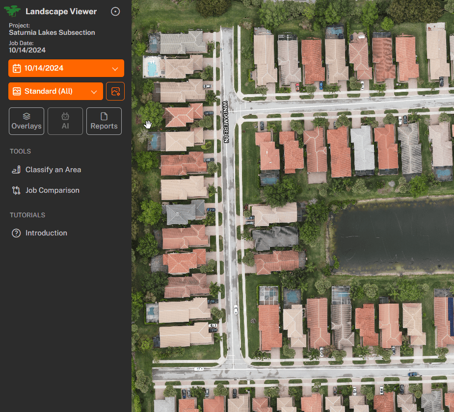
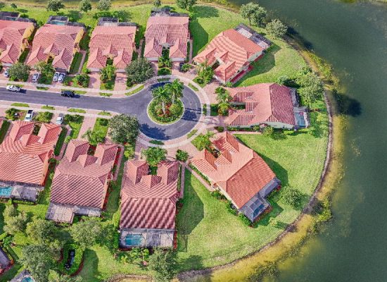
View entire communities
Our drone based landscape management tool starts with complete documentation of the entire project in one image. This makes the process of viewing projects extremely natural. How long would it take you to walk the whole property or an inspection?

Generate Reports
Easily customize reports with a click, simplifying project management. Our intelligent PDF features allow you to open GPS coordinates in your device’s map app, enabling precise problem-solving and maintaining strong client relationships.
Craving More Info? Read our blog.

Discover the World of FPV Drone Videos
Introducing FPV Drone Videos: Experience a New Perspective FPV Drone...
Read More
Exploring Drone Altitude Limits: 400 ft Rule
Understanding the 400-Foot Rule: How High Can You Fly Your...
Read More
Accelerate Sales with Drone Videos
Selling Properties Faster with Drone Videography In today’s competitive real...
Read More